Ottawa’s Old Chinatown: A Practice in Unwilling Collaboration
or "Is This Stealing?": An Attempt at Transparency
The Assignment
At the beginning of the year, my digital history professor, Shawn Graham, walked into our classroom and told us that we were not enrolled in a traditional history course. “We’re going to be break things,” he said. “What you initially try to accomplish isn’t going to work. If you fail, that’s when you’re going to learn.” It was an intimidating, exciting start to the semester (and spoiler alert: He was right). Going on he instructed myself and my classmates to question the established narratives, disrupt the norm and intervene in a historical way. He expected us to produce projects that would cause others to do the same.
Over the first couple weeks we discussed the different avenues we could pursue in order to produce this disruption of history. We learned about pirate boxes (which, when one connects to their insular wifi, can offer downloadable material or an interactive website), game building software (like Aris, which allows you to build scavenger hunt like games using virtual items accessible through location GPS on your phone) , Augmented Reality (teaching our phone cameras to recognize images that would trigger new windows to open), and projection mapping. There is a very high likelihood that you’ve encountered projection mapping sometime in the past few years. This digital intervention creates images that can be projected onto irregular surfaces and while keeping their shape. Department stores use it for advertising campaigns, the government of Canada tells its national history with images projected onto Parliament, and guerilla artists project controversial images in public spaces to catch the eye of passers-by.
Projection Mapping appealed to me immediately. In my mind, its ephemeral quality pairs perfectly with the inherit accessibility of a publicly projected image. If someone was in the public space where I was projection mapping, there would be no barriers to them watching the production, and if the projection upset someone, the art would be gone the moment the projector was powered off. So, this was how my project started. I wanted to share a lesser-known history through images to broad public, and projection mapping was the tool to do so. Only… I didn’t know what history I wanted to tell.
”Discovering” Ottawa’s Old Chinatown
I’m new to Ottawa. I moved here for school eight months ago, and quickly familiarized myself with Somerset Street, starting in front of the beautiful welcome gate. Happily, I explored its restaurants, bubble tea shops and grocery stores. Although smaller than both Vancouver and Montreal’s Chinatowns, which I had become familiar with during my years living in each city, it had everything that I could ask for.
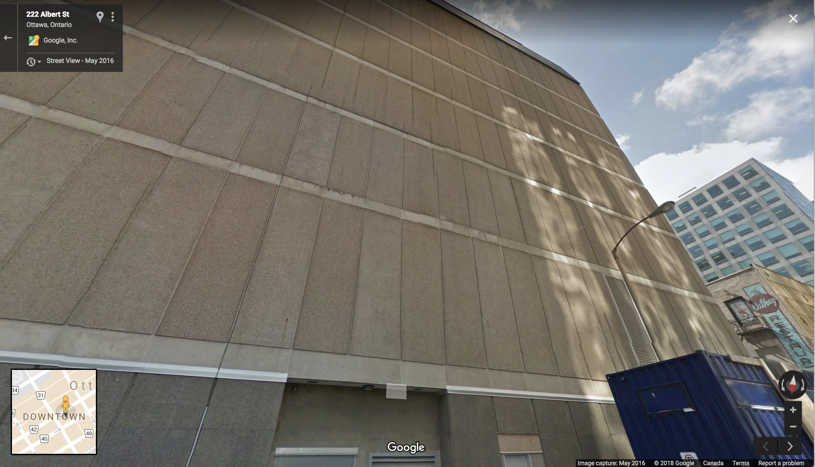
A long-time fan of historic Chinatowns, I decided to look into the history of Somerset Street, as a potential area to focus my projection mapping on. This is when I discovered that Chinese immigrants began establishing themselves along that street in the late 1960s. Before that, SFU’s Chinese Canadian History Public Education Project informed me, the hub of Ottawa’s Chinese community could be found on Albert Street between O’Connor and Kent. Curious about this “original Chinatown”, I ventured to Google Street view and discovered that the prominent Bell building that now runs along Albert features a wall that was virtually created for Projection Mapping. My plan was set in motion.
My search into the Old Chinatown yielded the main historical source for this project almost immediately- Lives of the Family is author Denise Chong’s recently published book on the first Chinese families who established themselves in the Ottawa Valley in the early decades of the 20th century. The book follows these families over generations, made rich with photographs and interviews with those family members. It was a wonderful launching point- but begged the question: Was I engaging with an already written history? Did I have anything to contribute to this history?
Talking with classmates and other friends from Ottawa, it became clear to me that the Chinese Community on Albert Street was still a relatively unknown part of Ottawa’s history. So, the history that I wanted to write would be based on location. It would feature businesses that although they closed decades ago, were staples of the early Chinese community. I would project images onto the side of the Bell building, and they would act as literal windows into the past- where those walking by would learn about the community that once walked the very streets that they were walking. Grounding my project on the businesses and the structures of the community would allow my project to stand as an independent exploration of the early Chinese community in Ottawa.
Making a Website for the First Time
I realized quickly that I wanted to make the website a companion to my projection mapping, in order to provide concrete historical information about this neighbourhood. The concept for the website was also based on highlighting the location and businesses of Ottawa’s first Chinatown. Therefore, an old map of Ottawa and pinned with the historic businesses in their authentic location served as the foundation of the website. Clicking on each pin would reveal the address of the business, and a brief informative paragraph about said business. Then, I developed four webpages that you can click through to after this short snippet of information. They give broader information on the history of the different types of establishments- groceries, laundries, restaurants, and social clubs, that made up the majority of Chinese property in the early twentieth century.
The website would also create a permanent digital home for the projection mapping videos, thus making that piece of digital history accessible to all interested in it. Essentially, the website could be a hub to pull together all of information collected in working on this project. However, as Shawn had warned at the beginning of the course, over the course of building this project I have been gaining information in a much more nuanced way than simply collecting research and conveying it through my own lens, as most masters students can essentially do in their sleep. I was learning about considerations such as who my audience would be; Who did I want my audience to be? How would readers who had a personal connection with this history react? How would citizens who work on Albert street perceive it? How much information would overwhelm or cause readers to lose interest? How could I portray my research in as balanced of a manner as possible? How could I challenge pre-conceptions held by readers from various communities? How can I tell this story with the authority gained from my research, while being cognisant of my position as an outsider to the community I am studying?
Simultaneous to conducting my research, I was also learning multiple new forms of media- specifically the projection mapping software mapmap and basic HTML for the development of this website. With digital experience that hit its limit at “I could google how to do that?”, I delved head first into creating the platform that was easily imagined, and less easily created. I learned how to re-purpose previously written code for my own site- to recognize what needed changing, adapting and what needed to stay to keep the site afloat. I learned to read through HTML message boards to find the code that best suited my purposes and learned not to try and fix HTML on a site that had content that I was already happy with, because it risked ruining the work that I had already accomplished. As Shawn had foretold, failure was exactly how I learned, especially when I had to fix those failings.
This is where I chronicle all those failures, and the occasional successes that followed. Both the ethical and methodological difficulties that I faced had direct impacts on the final product which you are accessing today. Therefore, for the sake of transparency, and potentially to help you out should you ever decide to undertake such a project, it is necessary that I address them.
Ethical Difficulties
In developing this project, I struggled with two different challenges in producing content that I felt was ethically sound. The first was the voice of authority that is inherit in a publicly published website. I spent my academic career leading up to this point writing for an audience of one- the professor grading my essays, maybe twenty if I presented my research at a conference. With such a limited audience I never felt wary of the authority that I took as narrator of the stories that I was writing about. However, in publishing an openly accessible website, the stakes are inherently higher. Putting information online means that someone who comes across the site would take that information at face value, and treat what I wrote as fact. This isn’t to say that I don’t feel confident about the research that I conducted and the stories that I’m sharing on this website. The material that is posted here is credible… from my perspective. There is no process of double-blind peer review for a website like this, and it’s the work of a singular person. Biases are unavoidable in any piece of writing, and I was forced to become especially aware of my own while writing the content for this site and editing my projection videos together. Was I picking information that was sensationalized to make the content more exciting? How could I keep the content a succinct and informative read while conveying as much meaningful information that I could? Would those reading the webpage come out with a certain perspective of these communities because of my word choice or the focus that I chose? Writing an objective history is impossible, and try as I might, I will always worry about my own subjectivity in my writing.
On the other hand, once I put the information online, I am choosing to give up some aspect of the authority that I have claimed in choosing to publish the content in the first place. Anyone who finds this website can take the information that I’ve published and manipulate it to suit their own interests. They can warp my projection videos, interpret my wording and make the content suit their own wills. This is, as we all know by now, inevitable on the internet. However, that doesn’t mean that it doesn’t make me very uncomfortable. The moment the site is live, the moment it is public, I lose the ownership that I had in the making process.
My second difficulty was facing my inner voice expressing that perhaps this is not my story to tell. I am a half-Chinese Canadian, but my Chinese family are recent immigrants to Canada compared to the families whose stories were woven into the businesses and clubs that I was writing about. Moreover, I’m from Vancouver, which is far removed from the Chinese Canadian experience in Ottawa. In my attempts to reach out to the Chinese community in Ottawa I was unsuccessful- with no-response emails and unsuccessful phone calls and twitter DMs. Yet I persevered in writing the history. Unable to connect with the families to whom this history belongs, I used other methods, particularly newspaper research to find my stories. However, this also limited my information to what the Ottawa Journal decided was newsworthy. This undoubtedly resulted in my paragraph on perceptions of criminal activity in Chinese Social Clubs, as there were many articles on those subjects publish. Ultimately, in the four months that it took me to research and create this project, I did not have the chance to establish myself within the community, nor to connect with the people whose histories I am trying to tell. There is not avoiding this fact. The website reflects this. Yet, it is a story that I think is important to tell, and this project intended to tell it in a unique way. Using the map to navigate, and videos to create my “window to the past”, I hope that as an outsider I brought something productive to the history. I hope that my perspective adds a fresh look at the stories already being told.
Methodological Difficulties
My technical challenges were numerous, and a direct result of my complete inaptitude at working with technology. I started with the shell of a website that Shawn had introduced us to, and from there worked to figure out how exactly I wanted to adapt it to suit my needs. This meant reading through the HTML and making changes to the images, titles, and content. Some of these changes came easily, while others took hours of fiddling around with code, CSS and reading through forums. My first challenge was uploading a vintage map of Ottawa and rectifying it, so that I could accurately pin the locations of the seven Chinatown businesses that I had chosen to feature. I used the application Map Warper, and matched points on the map to those on google maps in order to ascertain the coordinates would match with the pins on my website. It took a couple tries, but I was able to line up the map with the watercoloured background map, thus negating my back up plan to put Chinese style ceramic tiles behind the map. Once I had rectified the map, I needed to change the coordinates of the pins to match the businesses that I had chosen. In the aa-sites-popup csv I typed in the coordinates that I had found on google maps, thus pinning the correct spots on the rectified map. The one difficulty that I couldn’t overcome was how the vintage map would become pixelated when you try to enlarge the map- especially because all the pins are closely clustered together. However the proximity of the pins with each other emphasizes the closeness of the community, which I see as a benefit.
A second technological challenge that I faced was trying to create a side bar for the website, as there was none coded in the original website that I was using as the shell for my own. In order to make a side bar, I went to forums to look at how they were coding their HTML. It took a couple hours of copying and pasting CSS and the HTML without success before I decided to abandon my initial plan and try creating two containers. These containers were set to take up 1000px and 300px respectively. It worked, but only with a certain sized windows, until I switched to coding that the containers take up 75% and 20% of the window space. This meant that smaller screens could have the sidebar as well. I had similar HTML difficulties in trying to code padding and correct margins for the photos that I was inserting in the website. After multiple tries, I discovered that using “margin-left; 30px;” was the best way to create that space. For photos on the sidebar, I used them as links to the other site pages, by combining the code that I had found for linking words and photos and combining them together. This makes up the majority of the navigation between pages, aside of the navbar at the top of each webpage.
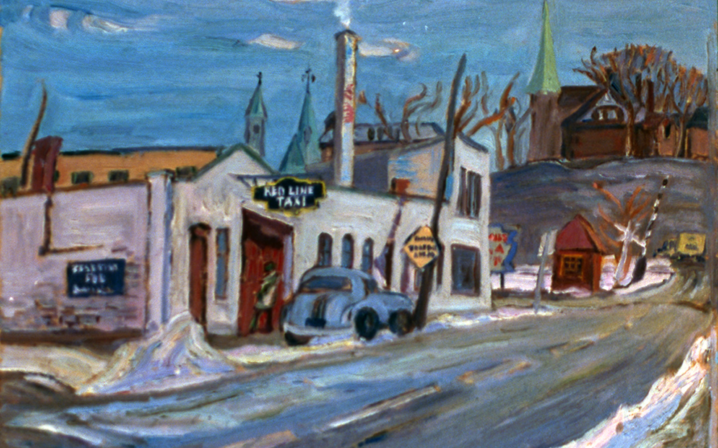
The challenges that I overcame in making the films were different, as I have previous experience using video editing software. For the films, finding photos and video clips that created the proper “window into the past” was my main goal. Most of the archival images related to Ottawa that I found were from the Ottawa Journal- both advertisements and articles, but this left an unfortunate gap to fill with more visually interesting pieces. In order to overcome this, I did two things. Firstly, I found photos that were available online that were not from Chinatown in Ottawa but maintained a feeling that was authentic to the stories that I had found in my research. For example, an image of a Mahjong table represented the social clubs, even if it was not taken in Ottawa during the 1920s. Similarly, I looked for old footage of Ottawa on Youtube, which would give the atmosphere of the city of Ottawa during that period, even if it didn’t focus on the Chinese residents. Finally, the least historically accurate, but most visually engaging media that I wanted to integrate was footage of people partaking in actions that were related to the different businesses that the videos focused on. The videos of laundromats and grocery shopping were the farthest removed from Ottawa’s Chinatown in terms of their historical accuracy. However I felt that they added to the atmosphere and visual interest, and were thus important to include in the final projection mapping videos. They depicted actions that could relate the viewers to the photos and newspaper clips, making the videos relatable for those passing by. Had I found footage from Ottawa’s old Chinatown, then I could have used that for my videos. Since I was not able to that, I adapted and made videos that had the authenticity and atmosphere that I wanted.
 ;
; 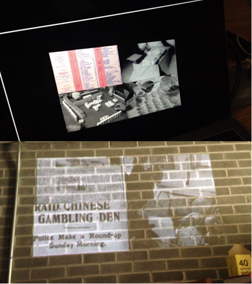
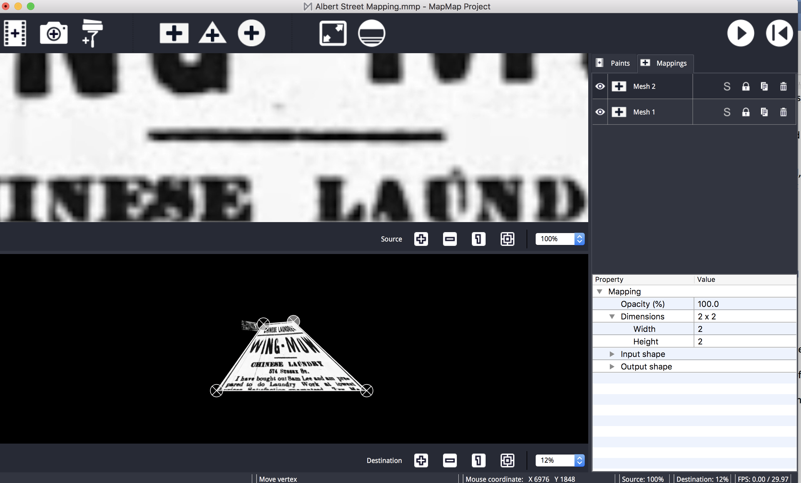
Finally, the projection mapping. I used the mapmap software for presentating my videos. This consisted of uploading my four videos onto mapmap, and connecting my computer to a projector to project them onto the wall. However, I had made the videos in such as way that they needed to but matched together, as they started clips that made up the four quadrants of the same video that I had taken on Albert Street. The process of matching these videos up was frustrating, and consisted mostly of trial and error. The space available on the bottom mapmap screen is limited, so I had to shrink each video significantly in order to manipulate their edges. Once I shrunk the video sizes, I could open mapmap to full screen and using marks on the brick wall, match them up with the most possible accuracy. Making the videos small before opening the full screen on mapmap made it a lot easier to line up the projections to match.
Although I was able to project my videos onto a school wall, I never got the chance to project them onto the Bell building, as I had originally planned. Time constraints, and a lack of power source for the projector, and weather limited my ability to follow this project to completion. Perhaps when I return to Ottawa in September I will have the chance to execute the final stage of the project. Until then, the projection that I recorded for this website will be a place holder for the real event.
Concluding Thoughts
This project is by no means complete. It’s a starting point for myself to learn about various technologies that I haven’t had a chance to work with. It’s also a starting point for those who are interested in learning about the Old Chinatown in Ottawa. Hopefully for both myself and anyone reading this, the learning process will continue. Should I find more content, the site could shift and change, and should anyone reading it reach out to me with criticism or feedback, that would change it as well. In that way, it will never be complete. However, this is where it stands today – a chronicle of both a neighbourhood’s history and my own experiences trying to share them with you.